William Smith (1769–1839), often hailed as the “Father of English Geology,” is renowned for creating the first detailed geological map of England and Wales in 1815. His pioneering work laid the foundation for modern stratigraphy and significantly advanced the understanding of geological formations. Smith’s background was modest; born in Churchill, Oxfordshire, he was largely self-taught and began his career as a surveyor and canal engineer. His observations of rock strata during canal construction projects led to his groundbreaking insights into the layering of rocks and the use of fossils for dating strata.
Smith’s 1815 map, titled “A Delineation of the Strata of England and Wales with Part of Scotland,” was monumental in scale and ambition. It measured over 8 feet tall and nearly 6 feet wide when assembled from 15 engraved and watercoloured sheets. It was the first map to show the distribution of rock types across a whole country based on stratigraphy and fossil content—an unprecedented achievement in geological science.
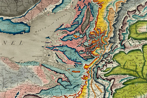
Only around 70 copies of this original 1815 map are known to have survived. The University of Bristol holds its very own copy which is on display in the School of Earth Sciences in the Wills Memorial Building. The archives at the University of Bristol Special Collections also contain several of Smith’s individual sheets.
While Smith’s contributions to geology are well-documented, there is limited information directly linking him to colonial enterprises or activities. His work primarily focused on the geology of Britain, and his professional endeavors were centered around surveying and mapping within the country. However, it’s important to note that the broader context of 18th- and 19th-century scientific exploration, including geology, was often intertwined with colonial expansion and exploitation. Scientific findings during this period frequently supported colonial interests, such as resource extraction and territorial claims.